ALR PR1HikingOfficially certified trail
Ribeira de Muge, um Tesouro Natural
Almeirim, Santarém
Difficulty
Easy
Distance
11 km
Elevation gain
134 m
Altitude
37–132 m
Type
Loop
Description
Machine-translated from Portuguese.
This trail runs along the Muge Stream, one of the tributaries of the
Tagus River, and through the surrounding countryside, which consists of well-preserved
cork oak forests and a fertile floodplain suitable for agriculture.The
starting point, in the square next to the Casal da Tira Bridge, offers convenient
parking and on-site dining options. The route continues
westward along the village’s main street. A typical rural village with
its single-story houses, farm outbuildings, vegetable gardens, and orchards. Small
vineyards for personal consumption also dot the landscape. At the end of the
settlement and the paved section, the rest of the route is on dirt roads.
After these initial 1,000 meters, cork oaks begin to dominate
the landscape.
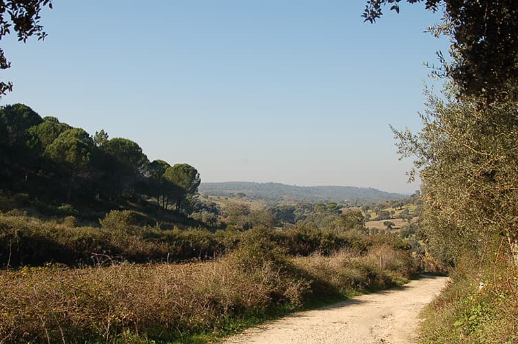
At the start of the dirt road, do not turn left; instead, continue straight ahead for about six hundred meters. At the “water source” sign, turn left.After this initial flat stretch, the climb to the highest point begins. This entire section runs through a cork oak forest where the song of many forest birds is a constant presence. The cork oak forests of the Iberian Peninsula provide an ideal habitat, offering food and shelter to many animal species; more than 160 species of birds, 37 species of mammals, and twenty-four species of reptiles and amphibians.
Halfway the ascent, on the right-hand side, there is a small pond where some animals come to drink; it is possible to spot mammals such as the fox or wild boar (Sus scrofa)Here the path forks; take the right fork.
After about five hundred meters and near the summit, the trail joins another path. Here, take the left fork. This section runs between two continuous patches of forest. There are several forks here, but always keep to the right, with a scattered oak grove on your left and a denser pine forest on your right. In this area, you can find several strawberry trees (Arbutus unedo).After about nine hundred meters, turn right and continue the ascent through the middle of the pine forest. After about 150 meters, turn right again and continue along the main road along the ridge, now keeping the pine forest on your right and a heathland area on your left.
In this highest section, on days with good visibility, you can see Almeirim, Santarém, and the Aire Mountains. It’s also a good spot to spot large eagles such as the Common Buzzard (Buteo buteo) or the Short-toed Snake Eagle (Circaetus gallicus), which, as its name suggests, feeds mainly on reptiles—especially snakes, but also lizards.
Occasionally, it may hunt small mammals and, rarely, birds or insects.
After about 1,200 meters, turn right and cross the pine forest. From this point on, the trail begins its descent toward the Muge stream and the scattered oak-holm oak woodland. After about 100 meters, when the path forks, take the right fork, and after another 100 meters, turn left. Continue for about 150 meters and turn left again.
After another 100 meters, at the fork, turn right again and continue straight ahead for about 400 meters until you reach the picnic area at Fazendas de Almeirim.
Here there is a spring that feeds the Vale d’Água fountain and several tables that invite you to take a break. Many bird species can be found here, such as the Great Tit (Parus major). Next to the fountain, on your left, there is a small pond, and in front of you, the streamside vegetation. Follow a short trail and cross a small footbridge to the other bank. Here, turn right. Now, on your way back to the starting point, the route remains flat all the way along the Muge stream and its dense tree-lined banks.
Continue straight ahead along the Muge stream, with several farm fields, orchards, and vineyards on your left. This floodplain is very fertile and ideal for agriculture because, due to the gentle slope, during flood season, the river overflows its original banks and floods the adjacent fields.
You’ll cross a paved road, and several paths will appear on your left, but keep going straight ahead. After about two thousand meters, the road seems to end and turn to the left. At this point, continue straight ahead along a narrow trail through dense vegetation, keeping the water’s edge on your right.
After about two hundred meters, you’ll come to a dirt road again. Continue straight ahead, with a fenced-in field on your left, sometimes with animals.After about seven hundred meters, you’ll come to a paved road. Here, turn right, cross the bridge, and you’ll be back at the starting point.
At the start of the dirt road, do not turn left; instead, continue straight ahead for about six hundred meters. At the “water source” sign, turn left.After this initial flat stretch, the climb to the highest point begins. This entire section runs through a cork oak forest where the song of many forest birds is a constant presence. The cork oak forests of the Iberian Peninsula provide an ideal habitat, offering food and shelter to many animal species; more than 160 species of birds, 37 species of mammals, and twenty-four species of reptiles and amphibians.
Halfway the ascent, on the right-hand side, there is a small pond where some animals come to drink; it is possible to spot mammals such as the fox or wild boar (Sus scrofa)Here the path forks; take the right fork.
After about five hundred meters and near the summit, the trail joins another path. Here, take the left fork. This section runs between two continuous patches of forest. There are several forks here, but always keep to the right, with a scattered oak grove on your left and a denser pine forest on your right. In this area, you can find several strawberry trees (Arbutus unedo).After about nine hundred meters, turn right and continue the ascent through the middle of the pine forest. After about 150 meters, turn right again and continue along the main road along the ridge, now keeping the pine forest on your right and a heathland area on your left.
In this highest section, on days with good visibility, you can see Almeirim, Santarém, and the Aire Mountains. It’s also a good spot to spot large eagles such as the Common Buzzard (Buteo buteo) or the Short-toed Snake Eagle (Circaetus gallicus), which, as its name suggests, feeds mainly on reptiles—especially snakes, but also lizards.
Occasionally, it may hunt small mammals and, rarely, birds or insects.
After about 1,200 meters, turn right and cross the pine forest. From this point on, the trail begins its descent toward the Muge stream and the scattered oak-holm oak woodland. After about 100 meters, when the path forks, take the right fork, and after another 100 meters, turn left. Continue for about 150 meters and turn left again.
After another 100 meters, at the fork, turn right again and continue straight ahead for about 400 meters until you reach the picnic area at Fazendas de Almeirim.
Here there is a spring that feeds the Vale d’Água fountain and several tables that invite you to take a break. Many bird species can be found here, such as the Great Tit (Parus major). Next to the fountain, on your left, there is a small pond, and in front of you, the streamside vegetation. Follow a short trail and cross a small footbridge to the other bank. Here, turn right. Now, on your way back to the starting point, the route remains flat all the way along the Muge stream and its dense tree-lined banks.
Continue straight ahead along the Muge stream, with several farm fields, orchards, and vineyards on your left. This floodplain is very fertile and ideal for agriculture because, due to the gentle slope, during flood season, the river overflows its original banks and floods the adjacent fields.
You’ll cross a paved road, and several paths will appear on your left, but keep going straight ahead. After about two thousand meters, the road seems to end and turn to the left. At this point, continue straight ahead along a narrow trail through dense vegetation, keeping the water’s edge on your right.
After about two hundred meters, you’ll come to a dirt road again. Continue straight ahead, with a fenced-in field on your left, sometimes with animals.After about seven hundred meters, you’ll come to a paved road. Here, turn right, cross the bridge, and you’ll be back at the starting point.
Nearby trails
APC PR1